Many people who study weather will think that the definitional
equation of potential temperature is strange.
I had a question.
”What is energy required to
compress?”
However, I was not able to find the description in a textbook.
I came to think as follows.
What is
potential energy.
1. Hydrostatic Pressure Balance Again
Since we need a hydrostatic pressure balance, it repeats.
The formula of balance is as follows.
AP(z+Δz)+Mg=AP (z) (1-1)
It was as follows when arranged.
V(z)dP(z)+nmgdz=0 (1-2)

2. Potential Temperature
It is as follows, if P(z) V(z) =nRT (z) is substituted for (1-2)
and it arranges.
dP(z)/P(z)+mgdz/RT(z)=0
(2-1)
If it uses and integrates with mean temperature T' instead of T
(z) of (2-1), it will become a hypsometric formula, but you should not use T' .
The dry adiabat lapse rate was as follows.
dT/dz=-mg/Cp (2-2)
It asks for the definitional equation of ordinary potential
temperature from (2-1) and (2-2).
dP(z)/P(z) - (Cp/R)(dT(z)/T(z))=0
lnP(z) - (Cp/R)lnT(z)=Const1
(2-3)
We do not know height z of 1000 hPa.
We set the height to z=z1000.
This is as follows.
P(z1000)=1000 hPa
Moreover, suppose that P (z) became 1000 hPa.
And we define the temperature as θ1.
The following relation consists of (2-3).
lnP(z) - (Cp/R) lnT(z) =lnP(z1000) - (Cp/R) ln (θ1) =Const1
lnP(z) -
(Cp/R) lnT(z) =ln(1000) - (Cp/R) ln(θ1) =Const1 (2-4)
Let's continue operation.
(Cp/R) ln(θ1/T (z)) =ln (1000/P (z))
θ1=T(z) (1000/P (Z))^(R/Cp) (2-5)
Thus, it becomes a definitional equation of potential temperature.
On the other hand, the dry adiabat lapse rate (2-2) is as
follows.
CpT (z) +mgz=Const2
(2-6)
It is as follows, if ideal
gas is compressed and T (z) becomes θ2.
CpT(z)+ mgz=Cpθ2+mgz1000
Cpθ2=CpT(z)+mg (z-z1000) (2-7)
θ2=T(z)+(mg/Cp) (z-z1000)
(2-8)
Both of θ1 and θ2 are same.
They are based (2-2).
(2-5) and (2-7) have
something not changing.
They have a law of preservation.
(2-7) is intuitively understood that it is energy.
(2-5) was the result of keeping entropy from changing.
Look (2-7) again.
CpT (z) is the energy called enthalpy.
mg (z-z1000) is a difference of potential energy.
Potential temperature is understood by enthalpy (it is ambiguous)
and potential energy.
For example, when energy is added to ideal gas, if all the
energies change to enthalpy, entropy may not change.
I do not know reason why you are using strange (2-5).
It may be for a meteorological model using the atmospheric
pressure P instead of z.
But entropy is hidden and is used.
It
confuses young people who study the weather.
3. Equivalent potential Temperature
It turns out intuitively that CpxT(z)+mgz=Const2 (2-6) is
expressing the principle of conservation of energy.
Although it is somewhat unclear, when (2-6) is realized, entropy
does not change.
Now, as for actual air, vapor is contained.
So to speak, (2-6) is a principle of conservation of energy of dry
air.
Latent heat is required for the principle of conservation of
energy of air with vapor.
In quest of latent heat, the quantity of vapor is required.
The
quantity of vapor can be calculated from the law of partial pressure.
In the atmosphere of the atmospheric pressure P and the water
vapor pressure e, the vapor which exists per 1 mol of air is as follows.
e/P (mol)
The dry air which remained is as follows.
(P-e)/P (mol)
You assume that there is little vapor.
Then, an average molecular mass can be approximated by dry air.
A new principle of conservation of energy is as follows.
{(P-e) /P} CpT+mgz+(e/P) L=Const3 (3-1)
(please do not forget that
P, e, and T are P (z), e (z), and T (z).)
Here, It compresses to 1000
hPa so that energy (=Const3) and entropy do not change.
In this
time, it compresses using potential energy and latent heat.
However, it is necessary to use all the vapor as ice.
Moreover,
ice is discarded outside.
********************
I stroll around a few.
You may think that it is unrealizable...
In quest of equivalent potential temperature, the following three
process is required.
A: Use vapor as ice* without changing entropy and total
energy.
B: The energy which remains in ice is disregarded noting that it
is small.
We throw away ice outside.
C: Compress to 1000 hPa, without entropy and total energy changing
the dry air of B.
Equivalent potential temperature is the temperature of C.
Energy required for compression uses potential energy.
Since all potential energy is changed into enthalpy, total energy
is not changed.
*At the Meteorological Agency of Japan, vapor is calculated by
using it as ice. Probably, I think that it is the same also in your country.
Probably, the next English expression will be no good...
Some Japanese textbooks said as follows.
An air parcel is raised and is expanded.
All the water vapor of the air is used as a liquid or a solid.
A liquid and a solid are discarded outside.
Next, it takes down to a height of 1000 hPa.
Equivalent potential temperature is temperature when it takes down
to a height of 1000 hPa.
I think as follows.
You took down the air parcel to a height of 1000 hPa.
But the
pressure of an air parcel is not 1000 hPa. ..
Explanation of a textbook differs from my explanation.
Although a
difference may be unknown for you, it will become clear sooner or later..
**********************
Equivalent-potential temperature θe is as follows from a principle of
conservation of energy.
{(P-e) /P} CpT+mgz+(e/P)L= {(P-e)/P} Cpθe+mgz 1000 (3-2)
θe=T+{P/(P-e)}+[ (mg/Cp)(z-z1000) ] {e/(P-e)} (L/Cp)
When we consider P(z) >>e (z), equivalent-potential
temperature is as follows.
θe=T+(mg/Cp)(z-z1000)+ (e/P) (L/Cp) (3-3) *
If Cp is applied to (3-3), you can check what energy each clause
is.
Please check and compare the definitional equation of equivalent potential temperature by
Wikipedia.
The weather defined potential temperature and equivalent potential
temperature intricately.
The definitional equation of the equivalent-potential temperature
seen by Wikipedia and (3-3) are the same contents.
If different, the definitional equation of strange equivalent potential
temperature is wrong.
(I confess that I suspect formula of Wikipedia,but it is not
confident. )
*Calculating equivalent potential temperature by (3-3) does not
recommend you. When severe weather is expected, it is rare to be able to
approximate with P/(P-e) =1. It is necessary to consider P/(P-e).θe and ept in WeatherFunction by Excel VBA consider this. The equivalent potential temperature of
most emagram is using (3-3). I think that the practical and educational role of
an emagram is finished.
4. Potential Temperature and Equivalent-potential Temperature
The atmosphere of the earth is not ideal gas.
I consider potential temperature and equivalent-potential
temperature as follows.
Potential temperature is the entropy of dry air.
Equivalent-potential temperature is the entropy of the air
containing vapor.
But, potential temperature and entropy are not saying that it is
the same at all.
The relation between potential temperature and entropy is as
follows.
A: Potential temperature high up in the sky is high.
B: Entropy high up in the sky is small.
A and B are the same things.
If the following θ,potential temperature, and θe , equivalent-potential
temperature, is used, two air parcel is comparable.
θ=T+ (mg/Cp) (z ‐ z1000)
(1‐8)
θe=T+(mg/Cp) (z ‐ z1000)+(e/P) (L/Cp) (3‐2)
I make potential temperature an example.
We consider the following states.
925hPa θ925=300k.
And
850hPa θ825=295k.
θ925 and θ850 stuff air into a balloon, and they are interpreted as
the temperature compressed into 1000 hPa without changing entropy.
The energy used for compression is potential energy.
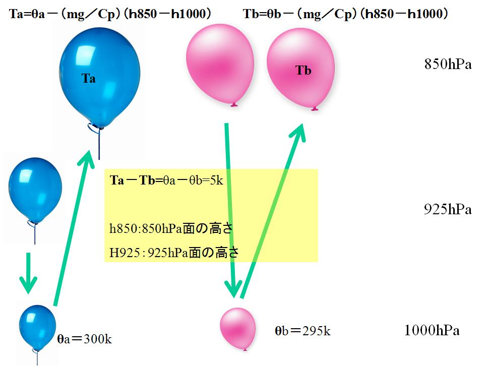
h850 is a height of
850 hPa. And h1000 is a height of 1000 hPa.
The energy surplus in expansion is stored as potential energy.
From (1-8), even if it lifts balloons, the difference in
temperature does not change.
Next, only a blue balloon is lifted.
It raises to 850 hPa using enthalpy (CpT).
A pink balloon is the same as a surrounding temperature.
A blue balloon becomes higher 5 ℃ than a pink balloon.
A blue balloon will be smaller than the mass density of the
surroundings, and Buoyancy will be got.
It can have the
argument also with same equivalent-potential temperature.
5. Saturation Equivalent-potential
Temperature
The equation of state of vapor is
not PV=nRT. Vapor is not ideal gas.
For example, vapor cannot be set
to 13 hPa or more if temperature is 10 ℃.
If water vapor pressure is 12 hPa
in 10 ℃ of
temperature, it is 100% of relative humidity.
The equivalent potential
temperature assumed to be 100% of relative humidity is called saturation
equivalent potential temperature.
If saturation equivalent potential
temperature is compared with equivalent potential temperature, the atmosphere
understands being stability or whether it is unstable.
Here, let's consider the state of
100% of relative humidity.
It reconfirms what kind of
relation to water vapor pressure and temperature and dew point temperature.
a) In 100% of relative humidity,
temperature and dew point temperature become the same value.
b) When dew point temperature is
high, water vapor pressure is high.
c) With the same atmospheric pressure, when water vapor
pressure is high, there is much water vapor content.
Next, the relation between
temperature and equivalent potential temperature is considered with the same
atmospheric pressure.
We assumed that relative humidity
was 100%.
High-temperature → Dew-point temperature is high→ Water vapor pressure is
greater. (5-1)
Moreover, the following can also
be said.
High-temperature & Water
vapor pressure is greater →Equivalent potential temperature
is high. (5-2)
Furthermore, the following results
are brought.
High-temperature → Equivalent potential
temperature is high. (5-3)
It is because the following thing
can be said from (5-1).
High-temperature → Water vapor pressure is greater.
On the contrary, the following
thing can be said.
High equivalent-potential
temperature →Temperature
is high.
We assume 100% of relative
humidity.
And we got the important following
conclusions here.
* It is high-temperature if equivalent-potential temperature
is high with the same atmospheric pressure.
We need to consider the following
states.
B: At 850 hPa equivalent-potential
temperature 300k. And
At 500 hPa saturation equivalent-potential temperature 290k
An 850-hPa air parcel is filled in
a blue balloon, is enthalpy(CpT ) used, and is raised.
If enthalpy is used, temperature
will fall.
If temperature falls, relative
humidity will be 100% from the middle.
If it reaches to 100%, it will
raise also using the latent heat of vapor.
In such work, it is carried out so
that total energy and entropy may not be changed.
Although a blue balloon will
be 500 hPa , equivalent potential
temperature is still 300k. And the humidity is 100%.
500 hPa saturation
equivalent-potential temperature is 290k.
We assume 100% of humidity.
Please remember the conclusion
like next.
* It is high-temperature if equivalent-potential
temperature is high with the same atmospheric pressure.
A result is as follows.
A blue balloon becomes higher than
500hPa surrounding temperature.
This conclusion means that the
mass density of a blue balloon is low.
If 850 hPa equivalent potential
temperature is higher than the saturation equivalent potential temperature
which is 500 hPa, it can be said that the atmosphere is unstable.
I explain SSI briefly.
Two temperature is defined as
follows.
Temperature is T850 →500 when a blue balloon is
compressed into 500 hPa.
The temperature of 500 hPa is T500.
SSI (Showalter
Stability Index) is as follows.
SSI=T500-T850→500
There is no name of T850→500 in Japan.
It is the cause by which this
makes SSI difficult.
Equivalent-potential temperature
and saturation equivalent-potential temperature are usually described as
follows.
θe: Equivalent-potential temperature
θe*: Saturation equivalent-potential temperature
I claim strongly as follows.
The weather engineer has to check
the relation between SSI and θe*(500)-θe (850).
θe (850) is equivalent-potential temperature at 850hPa
θe*(500) is saturation
equivalent-potential temperature at 500hPa

It was a comfortable ascent hill.
6. Emagram by potential
temperature
They are the examples using an
emagram by potential temperature
Although it is an example outside an area of responsibility, I
think that a remarkable phenomenon is an object.
00Z is 09:00 a.m., and 12Z is 21 00 at Japan.
SSIはプラス:SSI is plus.

Note
The
value of potential temperature is already the same to 500 m.
It is
a state where the air near the ground is raised to 500 m by solar radiation.
This
is the cause of moisture of 500~1000 m.
A
level of free convection is as high as 2000 m.
The
conditions which cause a convection are the ground temperature 304k (334-273=31
℃).
If ground temperature exceeds about 30 ℃, a convection will
start.
ノート
すでに500mまで等温位になっている。地上付近の空気は日射ですぐに500mまで持ち上がる。
持ちあがった空気が500~1000mの湿りの原因と考える。
自由対流高度は2000mと高いが、これを超える条件は温位から地上気温304k(334-273=31℃)。
地上気温が約30℃を超えれば一気に対流が始まる。

Note
I worry
about this case very much.
A
level of free convection is as high as 2000 m.
Near
the ground is dried.
However,
it is hard to go up ground temperature for inclination of potential
temperature. *
Temperature
guidance is corrected or needs to be inquired(‐1℃).
Both
CAPE and SIN can read a large thing.
When the cold goes into a lower layer (850
hPa), the convective clouds which are the cloud top height of 10000 m may be
made.
* This
is my empirical rules. I expect what you are convinced to in the future. You
should consider why potential temperature inclines.
ノート
非常に心配されるケース。
自由対流高度は2000mと高い。
地上付近は乾燥しているが、温位の傾きがあり地上気温は上がりにくい。
(気温予想はガイダンスをマイナス1℃修正するか検討が必要)
CAPEとSINはともに大きいことが読みとれる。
下層(850hPa)に寒気がはいると雲頂高度10000mの対流雲ができてもおかしくない。

Note
A Level of free convection is between A and B.
θe is large from the ground to 700 m.
Cloud
top height may reach to 12000 m.
CAPE is still larger although SIN is
large.
Although a level of free convection is
high, the thickness of the mixed layer* is over 700 m.
* In
this case, I consider the mixed layer to be a layer which is the value with
same potential temperature.
ノート
自由対流高度はAとBの間にある。
θeが地上から700mまで大きい。
対流が起これば雲頂高度は12000mまで達してもおかしくない。
SINは大きい。
CAPEはかなりおおきいと判断できる。
自由対流高度は高いが、混合層(等温位となっている層)の厚さは700mを超えている。
**********
気象を勉強する多くのひとたちは、温位の定義式が奇妙だと思います。
私は圧縮するのに必要なエネルギーは何かと言う疑問をもちました。
しかし、私は教科書にその記述を見つけることができませんでした。
私は次のように考えるようになりました。
答えは位置エネルギーです。
1.静水圧平衡再び
静水圧平衡が必要ですので繰り返します。
必要な方は乾燥断熱減率を見てください。
釣り合いの式は次のとおりです。
A×P(z+Δz)+Mg=A×P(z) (1-1)
整理すると次のようになりました。
V(z)dP(z)+nmgdz=0 (1-2)
2.温位
(1-2)にP(z)V(z)=nRT(z)を代入して整理すると次のようになります。
dP(z)/P(z)+mgdz/RT(z)=0 (2-1)
(2-1)のT(z)の代わりに平均温度T´を用いて積分すると測高公式になりますが、T´など用いるべきではありません。
乾燥断熱減率は次のようになりました。
dT/dz=-(mg/Cp) (2-2)
(2-1)と(2-2)から普通の温位の定義式が求められます。
dP(z)/P(z)-(Cp/R)(dT(z)/T(z))=0
lnP(z)-(Cp/R)lnT(z)=Const1 (2-3)
私たちにとって1000hPaの高さzは不明ですがその高さをz=z1000とします。
これは次の通りになります。
P(z1000)=1000 hPa
また、P(z)が1000hPaの時の温度をθ1とすると(2-3)から次の関係が成り立ちます。
lnP(z)-(Cp/R)lnT(z)=lnP(z1000)-(Cp/R)ln(θ1)=Const1
lnP(z)-(Cp/R)lnT(z)=ln(1000)-(Cp/R)ln(θ1)=Const1 (2-4)
演算を続けます。
(Cp/R)ln(θ1/T(z))=ln(1000/P(z ))
θ1=T(z)(1000/P(Z))(R/Cp) (2-5)
このように普通の温位の定義式になります。
一方、(2-2)は次のようになります。
Cp×T(z)+mgz=Const2 (2-6)
P(Z)が1000hPaの時の温度をθ2、高さをz1000とおけば次のようになります。
CpT(z)+mgz=Cp×θ2 + mgz1000
Cp×θ2=Cp×T(z)+mg(z-z1000) (2-7)
θ2=T(z)+(mg/Cp)(z-z1000) (2-8)
(2-5)のθ1と(2-7)のθ2は2つとも(2-2)から求めた同じものです。
θ1=θ2=θ
なのです。
(2-5)と(2-7)は何かの保存量がもとになっているのが分かると思います。
(2-7)はエネルギーだと直感的にわかります。(2-5)はエントロピーが変わらないようにした結果です。
(2-7)を少し変形します。
Cp θ=CpT(z)+mg(z-z1000)
CpT(z)はエンタルピーと呼ばれるエネルギーです。
mg(z-z1000)は1000hPa面との位置エネルギーの差です。
エンタルピーと言うエネルギーがどう言うエネルギーか分かりにくいのですが、温位がエネルギー保存則で理解できます。
例えば理想気体にエネルギーが加えられた時、そのエネルギーが全てエンタルピーに変わればエントロピーは変わらないのかもしれません。
何故、奇妙な(2-5)を使うのか疑問です。
気象モデルはzの代わりに気圧Pを使うためかもしれません。
エントロピーが隠されそして使われています。
それは気象を勉強する若い人たちを混乱させます。
3.相当温位
Cp×T(z)+mgz=Const2 (2-6)はエネルギー保存則を表現しているのが直感的にわかります。
少し分かりにくいのですが、(2-6)が成り立つ時、エントロピーも一定なのです。
さて、現実の空気は水蒸気が含まれています。
(2-6)はいわば乾燥空気のエネルギー保存則です。
水蒸気のある空気のエネルギー保存則は潜熱が必要です。
潜熱を求めるには水蒸気の量が必要です。
水蒸気の量は分圧の法則から求めることができます。
大気圧P、水蒸気圧eの大気において、空気1モル当たりにある水蒸気は次のようになります。
e/P (mol)
残った乾燥空気は次の通りです。
(P-e)/P (mol)
水蒸気は少ないと仮定します。
すると、平均分子量は乾燥空気で近似できます。
新しいエネルギー保存則は次のようになります。
{(P-e)/P}CpT+mgz+(e/P)L=Const3 (3-1)
(P,e,TはP(z)、e(z)、T(z)であることを忘れないで下さい。)
ここで、エネルギー(=Const3)とエントロピーが変わらないように1000hPaまで圧縮します。
今回は、位置エネルギーと潜熱をつかって圧縮します。
しかし、全ての水蒸気は氷にする必要があります。また、氷は外に廃棄します。
*********************
私は少しぶらつきます。
相当温位を求めるには次の3つ過程が必要です。
A:エントロピーとトータルエネルギーを変えないで、水蒸気を氷にする*。
B:氷に残るエネルギーは小さいとして無視します。
あなたは氷を外に捨てます。
C:Bの乾燥空気をエントロピーとトータルエネルギーが変えずに1000hPaまで圧縮する。
相当温位はCの温度です。
圧縮に必要なエネルギーは位置エネルギーを使います。
位置エネルギーは全てエンタルピーに変えるので、トータルエネルギーを変化しません。
(日本の気象庁では、水蒸気を氷にして計算します。おそらく、あなたの国でも同じだと思います。)
日本の教科書は言いました。
空気塊を持ち上げて膨張させます。
空気の中の全ての水蒸気を液体や固体にします。
液体や固体は外に廃棄します。
次に1000hPaの高さに降ろします。
相当温位は1000hPaの高さまで降ろした時の温度です。
私は次のように考えます。
あなたは空気塊を1000hPaの高さに降ろしました。
しかし、空気塊の圧力は1000hPaではないのです。
私の説明と教科書の説明は違います。
あなたにとって違いが不明かもしれませんが、遅かれ早かれそれが判明するでしょう。
**************************
相当温位θeはエネルギー保存則から次のようになります。
{(P-e)/P}CpT+mgz+(e/P)L={(P-e)/P}Cpθe+mgz1000
(3-2)
θe=T+{P/(P-e)}(mg/Cp)(z-z1000)+{e/(P-e)}(L/Cp)
私たちがP(z)>>e(z)と考える時、相当温位は次のようになります。
Θe=T+(mg/Cp)(z-z1000) +(e/P)(L/Cp) (3-3)*
(3-3)にCpをかければ、それぞれの項が何のエネルギーであるか確認できます。
Wikipediaで相当温位の定義式を確認して比べてみてください。
気象は温位や相当温位を、複雑に定義しています。
Wikipediaにみられる相当温位の定義式と(3-3)は同じ内容なのです。
違っていれば奇妙な相当温位の定義式が間違っているのです。
(私は告白します。私はWikipediaの式を少し疑っています、しかし、自信がありません )
* 相当温位を(3-3)で計算するのはお勧めしません。
シビアウェザーが予想される時はP/(P-e)=1と近似できることが少ないのです。
氷にして外にした分を考える必要があります。
Weather Function by Excelにおけるθeやeptはこれを考えています。
エマグラムの相当温位は(3-3)を使っているものがほとんどだと思います。
私はエマグラムの実務的,教育的役割は終わっていると考えます。
4.温位と相当温位
地球の大気は理想気体ではありません。
しかし、私は空気が理想気体のように振る舞うことを経験から学びました。
私は温位と相当温位について次のように考えます。
温位は乾燥空気のエントロピーです。
相当温位は水蒸気を含んだ空気のエントロピーです。*
*
温位とエントロピーは全く同じと言うことではありません。
温位とエントロピーの関係は次の通りです。
A:上空の温位が高い。
B:上空のエントロピーが小さい。
AとBは同じ事です。
次のθ(温位)やθe(相当温位)を使えば2つ空気塊を比べることができます。
θ=T+(mg/Cp)(z-z1000) (1-8)
Θe=T+(mg/Cp)(z-z1000) +(e/P)(L/Cp) (3-2)
わたしは温位を例にします。
私たちは次のような状態を考えます。、
925hPa θ925=300k。そして、850hPa θ825=295k。
θ925とθ850は空気を風船に詰め込んで、エントロピ‐を変えずに1000hPaに圧縮した温度と解釈されます。
圧縮に使われるエネルギーは位置エネルギーです。
ブルー風船のh850とh1000とピンク風船のh850とh1000は異なりますが、その差は小さいとします。
5kの差があり925hPaの空気のほうが暖かくなります。
私たちはエントロピーとトータルエネルギーが変わらないように2つの風船を850hPaにします。
膨張で余ったエネルギーは位置エネルギーとして貯めるのです。
(1‐8)から、風船たちを持ち上げてもその温度差はかわりません。
次にブルー風船だけを持ち上げます。
エンタルピー(=CpT)を使って850hPaまで持ち上げるのです。
ピンク風船は周りの温度と同じです。
ブルー風船はピンク風船より5℃高くなります。
ブルー風船は周りの質量密度より小さく、浮力をもらうことになります。
相当温位でも同じような議論ができます。
5.飽和相当温位
水蒸気の状態方程式はPV=nRTではありません。水蒸気は理想気体ではありません。
例えば、気温が10℃なら水蒸気は13hPa以上になることはできません。
気温10℃で水蒸気圧が12hPaなら相対湿度100%です。
相対湿度100%と仮定した相当温位を飽和相当温位とよびます。
飽和相当温位と相当温位を比べると大気が安定か不安定か分かります。
ここでは相対湿度100%の状態について考えてみましょう。
気温、露点温度、水蒸気圧にどのような関係があるか再確認します。
a)相対湿度100%では気温と露点温度は同じ値になる。
b)露点温度が高いと水蒸気圧が高い
c)同一気圧では水蒸気圧が高いと水蒸気量が多い
次に同一気圧で気温と相当温位の関係を考えます。
私たちは相対湿度が100%であると仮定しました。
気温が高い→露点温度が高い→水蒸気量が多い (5-1)
また、次のようなことも言えます。
気温が高い & 水蒸気量が多い → 相当温位が高い (5-2)
さらに次のような結果になります。
気温が高い→相当温位が高い (5-3)
何故なら(5-1)から次のことが言えるからです。
気温が高い→水蒸気量が多い
逆に、次のことが言えます。
相当温位が高い→気温が高い
私たちは相対湿度100%を仮定しています。
そして、私たちはここで次のような重要な結論を得ました。
同一気圧で相当温位が高ければ気温は高い。
私たちは次のような状態を考えましょう。
B:850hPaの相当温位300k、500hPaの飽和相当温位290k
850hPaの空気塊をブルー風船に詰めてエンタルピー(CpT)使って持ち上げます。
エンタルピーを使うと温度が下がります。
温度が下がると途中から相対湿度が100%になります。
100%に達したら水蒸気の潜熱も使って、持ち上げます。
こうした作業ではトータルエネルギーとエントロピーを変えないように行われます。
やがてブルー風船は500hPaに成りますが相当温位は300kのままです。
そしてその湿度は100%になっています。
周りの500hPaの空気を湿度100%と仮定した相当温位(飽和相当温位)は290kです。
私たちは湿度100%を仮定しています。
先ほどの結論を思いだして下さい。
*同一気圧で相当温位が高ければ気温は高い。
結果は次のようになります。
ブルー風船は周りの500hPaの気温より高くなります。
この結論はブルー風船の質量密度が500hPaの空気より小さいことを意味しています。
850hPaの相当温位が500hPaの飽和相当温位より高いと大気は不安定だと言えます。
ここでSSIについて簡単にふれておきましょう。
次のように2つの温度を定義します。
500hPaまで圧縮したブルー風船の温度をT850→500
500hPaの気温をT500
SSI(ショワルターの安定指数)は次のようになります。
SSI=T500-T850→500
日本ではT850→500の呼び名がありません。
このことがSSIを難しくしている原因となっています。
普通、相当温位と飽和相当温位は次のように記述されます。
Θe:相当温位
Θe*:飽和相当温位
私は次のように強く主張します。
気象技術者はSSIとθe*(500)-θe(850)の関係を確認しなければなりません。
θe(850):850hPaの相当温位
θe*(500):500hPaの飽和相当温位
********************

The source of power of RCIC and HPCI is a difference in temperature of Reactor Pressure
Vessel and Suppression Chamber
********************
RCIC:Reactor Core Isolation Cooling system
HPCI:High Pressur Coolant Injection System
TEPCO:Tokyo Electric Power Company.
原子炉圧力容器:Reactor Pressure Vessel
圧力抑制室: Suppression Chamber
I thought before the accident that a
nuclear reactor could be cooled even if I lose electric power in a nuclear
power plant.
However, when the report was read, RCIC
automatic stay was carried out.
The TEPCO does not explain a reason at all.
It was told that HPCIS was stopped
automatically at the beginning.
At this time, that a nuclear reactor can be
cooled had only HPCIS.
However, in the report, the official in
charge changed having stopped freely.
In a report
A: The official in charge did not report the following thing.
Did the official in charge stopped HPCIS or stopped automatically?
B: About a boss, it is as follows.
He was not interested in the reason which stopped.
A and B are not an engineer's suitable actions.
If a report is true, there is no qualification for operating a
nuclear power plant to TEPCO.
A reporter is not trusted.
The source of power of RCIC and HPCI is a difference in temperature of Reactor Pressure
Vessel and Suppression Chamber
.
If HPCI is operated, a difference in temperature will become small.
It is said that the data of the time when HPCIS stopped does not
almost have a difference in temperature.
Data said that HPCI stopped automatically.
There is nothing in a report about the work which was required for
HPCI.
My guess is like this.
HPCI has stopped automatically.
The TEPCO did not think that HPCI stopped automatically.
I think as follows.
A report is accident hiding which the Ministry of Economy, Trade and
TEPCO conspired, and was made.
If it may make a nuclear power plant safely, but we does not have
the engineers who operate safely.
A fuel pool is a dangerous thing which shows the symptoms of China
syndrome, when water is exhausted.
Please check the picture of You Tube in the following address.
http://www.youtube.com/watch?v=GesM8SWr724
It knew that a steel frame would fall.
It is a fuel pool that the steel frame fell.
TEPCO did such terrorism.
0 件のコメント:
コメントを投稿